
The E4 Hiking Trail in Crete: Europe’s Long-Distance Path Across the Island

Few visitors realize that Crete is crossed by one of Europe’s great long-distance hiking routes.
The E4 European Walking Path stretches across the continent from Spain all the way to Greece and Cyprus. One of its most spectacular sections runs through Crete, where the trail crosses the island from west to east.
On Crete, the E4 runs roughly 500 km across the island, beginning near Kissamos in western Crete and finishing at Kato Zakros on the eastern coast.
Along the way, the trail passes through some of the island’s most dramatic landscapes:
high mountain ranges
deep gorges
remote coastal cliffs
ancient shepherd paths
traditional villages
For hikers who enjoy exploring nature slowly and independently, the E4 offers one of the most authentic ways to experience Crete.
The Landscapes of the E4
One of the reasons the E4 is so special is the diversity of landscapes it crosses.
Within a single week of hiking, you may walk through:
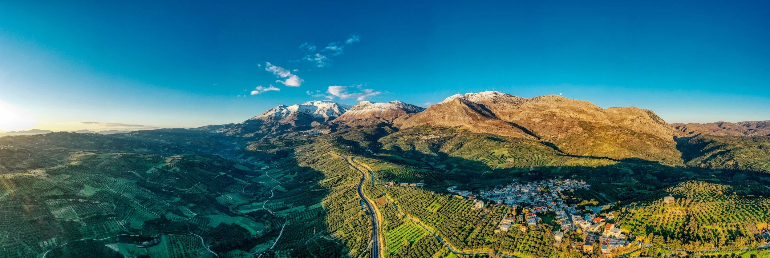
the White Mountains (Lefka Ori) in western Crete
famous gorges such as Samaria or Imbros
the rugged Sfakia coast
the mountains of Psiloritis and the Amari Valley
the eastern ranges of Dikti and the Lasithi plateau
The trail often follows ancient mule paths that connected villages long before modern roads existed.
These paths wind through olive groves, mountain passes, shepherd settlements and small monasteries, offering a glimpse into the traditional life of Crete.
Beautiful Sections of the E4 Near South Crete
While the entire trail crosses the island, several particularly beautiful sections lie close to South Crete.
These sections are perfect for hikers who want to experience the E4 without walking the entire island.
Agia Roumeli – Loutro – Chora Sfakion
This is one of the most famous coastal sections of the E4.
Starting at Agia Roumeli, the village at the exit of Samaria Gorge, the trail follows the coastline eastward past:
hidden coves
pine forests
the chapel of Agios Pavlos
the remote beaches of Marmara
The path eventually reaches the picturesque village of Loutro, before continuing toward Chora Sfakion.
Because much of this section runs close to the sea, hikers can combine walking with swimming stops along the way.
Paleochora – Sougia – Agia Roumeli
Another spectacular stretch runs along the remote south-western coast.
This section connects the villages of:
Paleochora
Sougia
Agia Roumeli
The trail passes ancient ruins, dramatic cliffs and small beaches that can only be reached on foot or by boat.
This part of the E4 is particularly popular with hikers who enjoy multi-day coastal trekking.
Mountain Sections in Central Crete
Further inland, the E4 climbs into the mountains of central Crete, including the areas around Psiloritis and the Amari Valley.
These sections pass through traditional villages, high plateaus and shepherd landscapes.
For hikers staying in South Crete, the mountains above Spili, Kedros and the Amari Valley provide access to several E4 segments that can be explored as day hikes or shorter treks from South Crete.
How Difficult Is the E4 in Crete?
The E4 is generally considered a challenging hiking trail, especially in mountainous sections.
Typical characteristics include:
long distances between villages
rocky and uneven terrain
steep ascents and descents
limited shade in coastal areas
Some stages can exceed 20 km per day with significant elevation gain, which is why many hikers plan their routes carefully and carry sufficient water and supplies.
However, it is not necessary to hike the entire route.
Many visitors simply explore individual sections of the trail, which still provide an unforgettable experience.

Trail Markings & Navigation
The E4 is marked throughout Crete using yellow and black signs or painted symbols on rocks and trees.
However, markings can sometimes be faded or inconsistent.
For this reason, most hikers now rely on:
When Is the Best Time to Hike the E4?
The best seasons for hiking in Crete are:
Spring (April – June)
Wildflowers cover the mountains and temperatures are ideal for long walks.
Autumn (September – October)
The sea remains warm while temperatures become more comfortable for hiking.
Summer hiking is possible, but many parts of the E4 are exposed to the sun and can become extremely hot, especially along the southern coast.
You can read more about seasonal conditions in our guide to Crete weather month by month.
Safety and Preparation
Hiking in Crete is generally safe, but the terrain can be demanding.
A few important tips:
start early during warm months
carry plenty of water
wear proper hiking shoes
check weather forecasts before longer routes
If you are new to hiking in Crete, our guide to safe hiking in South Crete offers practical advice for exploring the island’s mountains and gorges.
Hiking and Staying in South Crete
Many hikers use South Crete as a base for exploring the E4.
The region offers easy access to:
coastal E4 routes along the Sfakia coast
mountain trails near Psiloritis and Kedros
dramatic gorges and remote villages
After a long day on the trail, returning to a quiet terrace overlooking the sea is one of the pleasures of hiking holidays in Crete.
You can explore our collection of homes in South Crete if you are looking for a peaceful base for hiking adventures.