
The Ultimate Guide to Plakias, South Crete
Plakias has a creation myth, and it is unusually well-documented. In the 1961 census of Greece, the settlement was recorded for the first time as a distinct place — home to six permanent residents, all of them fishermen. That is the entire early history of Plakias as a village. Six people and their boats, on a beach at the mouth of a gorge, at the edge of the Libyan Sea.
What came before the fishermen was older and considerably larger. The Byzantine Emperor Nikephoros Phokas II built roads and bridges through this area in the tenth century to connect the mountain villages of Sellia and Myrthios, and the ruins of a fortified wall from that period can still be seen on a hilltop just northeast of the modern village. Eight kilometres to the east, the Monastery of Preveli was founded around the same time — a place whose subsequent history, through Ottoman occupation, Cretan revolutions, and World War II, is woven so deeply into the character of this coastline that it can hardly be separated from it.
Before that, the Minoans. The fertile valley formed by the Kotsifou River at its mouth — the flat ground that gives Plakias its name, from the Greek for flat — was never wilderness. It was always land that people found a use for. What it was not, until very recently in historical terms, was a resort.
What Plakias actually is
Understanding Plakias requires resisting the word "resort," which implies something that Plakias has deliberately not become.
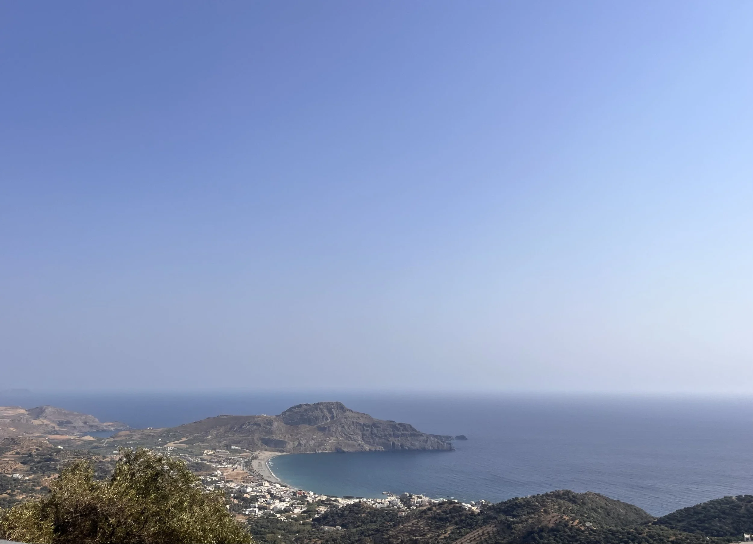
The village sits between two headlands at the western end of a wide bay, built along a single coastal road with the sea on one side and the first of the mountain slopes on the other. The permanent population as of the 2021 census was 119 people. In summer that number multiplies many times over, but the infrastructure never scaled up to match a large resort: there is no strip of beach clubs, no all-inclusive hotels, no nightlife of the kind that requires earplugs. What there is, is a long crescent of fine sand — one of the longer beaches in south Crete — a small harbour, a promenade, a sequence of tavernas and cafes that runs along the waterfront, and a set of small roads leading off into olive groves that end, eventually, at the hillside.
The word that recurs in almost every account of Plakias, from independent travellers who have been coming here for decades, is genuine. The people of Plakias, as one long-running guide puts it, have not changed with time. They still keep the Cretan tradition alive. This is easy to say and hard to earn — but Plakias, because it developed slowly and without the industrial-scale investment that reshaped parts of the north coast, has maintained something that larger resorts spent a long time trying to manufacture and eventually gave up on: the sense that ordinary life is happening here regardless of whether you are watching it.
The beach and the bay
The beach at Plakias — locally called Yialia, a name that covers the entire stretch of this bay — runs for roughly a kilometre from the village to the cliffs of Paligremnos to the east. The sand is fine, the bay shelves very gradually, and the swimming is calm enough for families with young children. The eastern end, backed by low dunes, is largely naturist by long-standing informal tradition and requires no particular mention to anyone who has visited before.
The Paligremnos rock at the eastern end of the beach is worth a closer look. The vertical cliff face that rises from the sea there attracts climbers, but the more unusual phenomenon happens from September through January: during full moons, the moonlight reflects off the cliff face in a way that apparently draws large squid to the surface of the water, which locals collect with sticks. This is the kind of specific, inexplicable local knowledge that distinguishes a place with actual residents from one without.
West of the village, reached by a short walk or drive, Souda Bay offers a longer, wilder alternative — quieter, with fewer facilities, the eastern corner traditionally used by naturists. Further along the coast, the road runs through to Rodakino, Frangokastello, and Sfakia, a coastal route that is one of the more rewarding drives on the south coast.
The beaches nearby
The coastline east of Plakias is where the landscape becomes exceptional.
Damnoni, a fifteen-minute walk or a short drive east, is a large sandy cove flanked by headlands, with sunbeds, a taverna, and the kind of water that photographs never quite manage to render accurately. Between Damnoni and Preveli there are several smaller bays — Amoudaki, Skinaria — accessible by short walks or boat, largely unknown outside the immediate area, and on most days outside high summer entirely empty.
Skinaria in particular, reached by a narrow road a few kilometres east, is one of those beaches that maintains a reputation as a secret through sheer inconvenience of access. A small diving school operates here; the underwater terrain is unusually varied. On a quiet morning, it is possible to sit on this beach and feel certain that nobody else knows about it. This feeling is almost certainly false, but it persists.
Preveli is the destination that earns Plakias its place on most itineraries, and it deserves its fame without exactly fitting into any conventional category of beach. More on it below.
Preveli: monastery, gorge and palm forest
Eight kilometres east of Plakias, the Kourtaliotis River exits the gorge it has carved through the mountains and meets the Libyan Sea at one of the most arresting points on the south coast.
The Kourtaliotiko Gorge itself — the same system whose karst aquifer is described in the STAYS Journal's piece on water in Crete — runs for about two and a half kilometres through limestone walls that reach 600 metres in height. Eagles nest in the caves. The river runs through it year-round. The walk from the village of Koxare is three kilometres and manageable without specialist equipment; stone steps descend to the church of Agios Nikolaos and the springs inside the gorge.
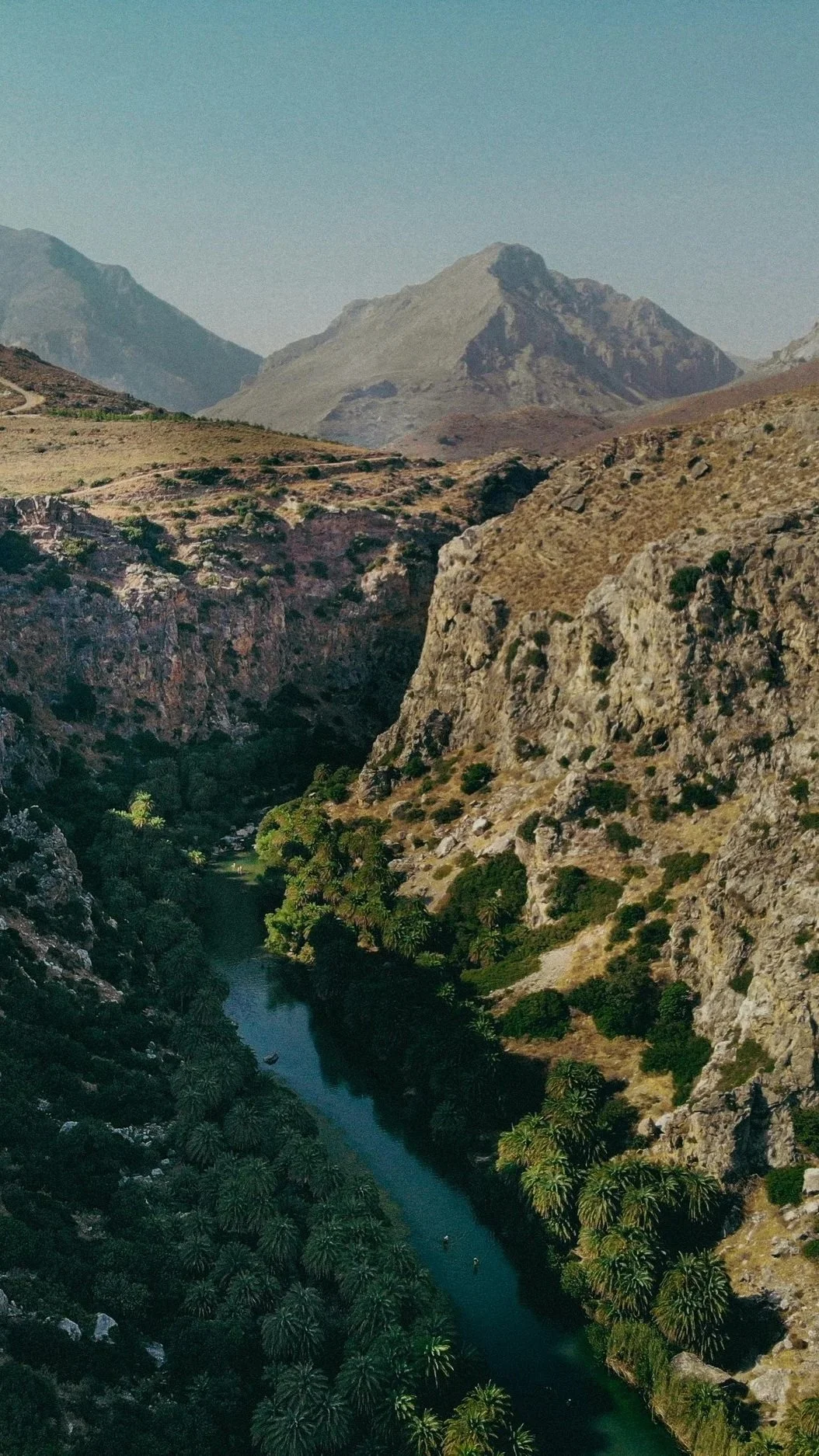
At the mouth, where the river meets the sea, is something that stops people mid-sentence. A dense forest of Cretan date palms — Phoenix theophrasti, an endemic species found in only a handful of locations in the Mediterranean — lines both banks of a river that broadens into a lagoon roughly 500 metres long before the sea. The combination of the gorge behind, the palm forest on the banks, the freshwater lagoon, and the sandy beach beyond it produces a landscape that feels categorically different from anything else on the south coast. The word that comes up repeatedly, and that is not quite wrong, is tropical.
The Preveli palm forest is the second largest in Crete after the one at Vai on the far east of the island. A fire in August 2010 destroyed approximately 70 percent of it. The recovery has been remarkable: Phoenix theophrasti turns out to have fire-resistance properties that were not fully understood until the blaze — the burned adult palms resprouted within the same autumn, and within a few years the forest had substantially regenerated. It remains, however, a reminder that this landscape is not immutable.
The beach at the river mouth is approached from above by a steep path from the car park, or by boat from Plakias in summer. The water is colder than most Cretan beaches because of the freshwater input. There are no changing rooms. There is a small taverna. The rock at the eastern end of the beach, shaped like a heart, has accumulated the predictable mythology. None of this matters much once you are there.
Above all of it, on a cliff overlooking the Libyan Sea, is the Monastery of Preveli.
The monastery that sheltered 5,000 soldiers
The Monastery of Preveli — formally the Holy Patriarchal Monastery of Saint John the Theologian — was founded by a feudal lord named Prevelis during the Venetian period, probably in the sixteenth or seventeenth century. It has been destroyed, rebuilt, looted, and rebuilt again across four centuries of occupation, and the pattern of destruction and return has shaped its character in ways that are immediately legible to anyone who visits.
Under Ottoman rule, the monastery was consistently at the centre of Cretan resistance. Abbot Melchizedek Tsouderos, who led the monastery in the early nineteenth century, was a member of the secret society organising the 1821 revolution against Ottoman rule in Crete, took part in battles personally, and was killed in 1823. The monastery paid for its resistance repeatedly — looted, its monks imprisoned, its buildings torn down — and rebuilt repeatedly, which is a fairly accurate summary of Cretan history in miniature.
The chapter that reaches furthest beyond the island's own story came in 1941. After the Battle of Crete — the German airborne invasion of May 1941, the largest airborne operation in military history at that point — around a thousand Allied troops remained scattered across the island after the official surrender on 1 June. British, Australian, and New Zealand soldiers, hidden by Cretan civilians in the mountains, were desperately searching for escape routes. The monastery became the collection point.
Over the weeks and months that followed, more than 5,000 Allied soldiers sheltered at Preveli, fed and hidden by the monks and local villagers at enormous personal risk. British submarines and small boats made contact with the coastline below the monastery to evacuate them to Egypt. The Germans, when they discovered what had happened, demolished the monastery on 25 August 1941, imprisoned many of the monks in Chania, and stole the monastery's most sacred relic — the Holy Cross of Ephraim, containing a fragment of the True Cross — though legend holds that the plane carrying it to Germany could not take off until the cross was returned to the local police.
The monastery was rebuilt after the war. A monument on the road approaching it commemorates the resistance. And in 1979, an Australian veteran named Geoffrey Edwards — one of those who had escaped through Preveli — founded a monastery near Perth named Prevelly, as a permanent expression of gratitude to the monks who had sheltered him.
The museum inside the current monastery holds icons, religious artefacts, and a modest account of this history. The view from the terrace, over the Libyan Sea on a clear day, is the kind that explains without further argument why people have been willing to die for this particular piece of coast.
The villages above
The hillside above Plakias holds a cluster of small villages — Myrthios, Sellia, Mariou, Asomatos — that are the main reason to have a car, and one of the main pleasures of staying in this area.
Myrthios sits directly above the bay, close enough that the view from its terrace tavernas takes in the entire sweep of the coastline from headland to headland. Plateia Myrthios is the natural choice for dinner on the hillside: traditional Cretan cooking, large portions at honest prices, a panorama of the bay at evening that justifies the drive up the narrow road several times over. Locals recommend it, which is a different and more reliable endorsement than any other.
Sellia, slightly further east, is quieter and older, a village of stone houses and winding lanes that has seen enough restoration to be attractive without losing the feeling of actual habitation. Mariou, reached by a road that becomes improbably narrow, has a taverna that several sources describe as a local secret — the kind that stops being a secret when enough people write about it, but that still feels like a discovery when you find yourself there on a Sunday with the locals.
Spili, twenty minutes north, is the main market town for the region and worth a morning. Its central fountain — a row of lion heads carved in stone, each spouting water from the spring above the village — is one of the more quietly memorable pieces of public infrastructure on the island. The springs at Spili are connected to the same karst system described in the STAYS Journal's water article; the water that comes from those lion mouths has filtered through the same limestone that holds 415 million cubic metres in reserve beneath the mountains.
The gorges
The Plakias area is one of the most gorge-dense parts of Crete, which is saying something on an island built largely of gorges.
The Kourtaliotiko has already been described. The Kotsifou Gorge, which opens directly above Plakias to the north and whose alluvial deposits literally built the ground the village stands on, is shorter but dramatic — sheer walls of grey and ochre limestone closing in over a road that winds through without stopping. It is the drive into and out of Plakias from the north, and most people experience it at speed without registering it as a separate thing. It rewards a slower approach.
For those who want to walk seriously, our guide to hiking in South Crete covers the routes in this area in detail, including the walk through the Kourtaliotiko to Preveli beach. Our guide on safe hiking in South Crete covers the practical considerations for summer walking, which are not trivial in a landscape this exposed.
Plakias as a base
The position of Plakias on the south coast is well-considered for anyone who wants to use their week to explore. Preveli is ten minutes east. The Palace of Phaistos — the second great Minoan site on the island, recently recognised as a UNESCO World Heritage Site — is forty minutes east along the coast road to Agia Galini and then inland. Rethymno, with its Venetian old town, its fortress, and the Archaeological Museum that houses artefacts from the wider region, is thirty-five minutes north. The Amari Valley — one of the most beautiful inland drives on the island, through Byzantine churches and mountain villages — is accessible within an hour.
For the question of how to divide a week between sites and beaches, our practical guide to how many days you need in Crete covers the balance honestly.
Where to stay
The accommodation landscape around Plakias runs from simple rooms above tavernas to carefully designed hillside villas with the full sweep of the bay below them.

The STAYS Home Collection includes several properties in and around the Plakias area that approach the question of where to stay from a different angle entirely. Sto Lofo and Aitherion sit on the hillside above the bay with private pools and views that take in the same coastline you see from the Myrthios taverna terrace — but from your own terrace, at your own hour, with nobody else's schedule involved. Both are available for exclusive hire and well-suited to those who want Plakias's natural and cultural richness as a backdrop to a week that is genuinely their own.
For those still deciding between Plakias and other parts of the south coast, our guide to where to stay in South Crete lays out the character of each area honestly. The south coast rewards deliberate choice; Plakias, in particular, rewards those who arrive knowing what it is — not a resort, not a spectacle, but a place that has been here, in various forms, for a very long time, and that has the texture to show for it.